|
|
TODAY.AZ / Politics
Azerbaijan to use space for defense purposes
29 May 2015 [09:21] - TODAY.AZ

By Nigar Orujova
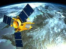
Azerbaijan may use the potential of its space arsenal for defense purpose by means of images obtained with low-orbit satellite AzerSky.
A workshop dedicated to the application of the satellite imagery acquired from Azersky, high resolution optical Earth observation satellite, into defence and security was held in the Main Satellite Ground Control Station in partnership with Airbus Defense & Space.
The main objective of the workshop was to demonstrate Azersky's capabilities, discuss existing application areas, and reveal new potential application areas in the format of mutual discussion.
Specialists of Azerbaijan's space agency Azercosmos and Airbus Defense and Space - manufacturer of the satellite, delivered presentations on technical specifications of the satellite, practical use of satellite imagery for military purposes, as well as supply, control and monitoring of military operations with geo-intelligence data.
The workshop aimed to educate potential beneficiaries. Organized in an interactive way, the workshop was attended by representatives of Azerbaijan’s power structures, such as the Ministry of National Security, Ministry of Emergency Situations, Ministry of Internal Affairs, Ministry of Defense, and the State Border Service.
Similar seminars, to be held by the end of this year will be dedicated to the application of satellite imagery into exploration and monitoring of natural resources.
Azercosmos is the first satellite operator in the Caucasus. Azerbaijan entered the space club with the launch of its first satellite Azerspace-1 in February 2013. By now, the country has three satellites, a telecommunication and two low orbit satellites, and it plans to launch a second telecommunication satellite in 2017.
Azersky was successfully launched into orbit last June and was handed over to Azercosmos in December 2014. The satellite is expected to operate for 12 years.
Azersky has a broad range of applications including defense and security, emergency response, exploration of natural resources, maritime surveillance, seafaring, environmental protection, urban planning, cartography, agriculture, and tourism.
The satellite is able to shoot portions of the surface of the Earth area of six million square kilometers daily. The resolution of the images is 1.5 meters.
During the next 1.5 years, more than 25 Azerbaijani professionals will be trained in France on optical satellite operations, product development, sales, and marketing of Geo-Information services.
URL: http://www.today.az/news/politics/141060.html
 Print version
Connect with us. Get latest news and updates.
See Also
- 28 August 2025 [14:34]
Azerbaijan joins CIS Deputy Prosecutors General meeting in Moscow - 28 August 2025 [11:33]
President Ilham Aliyev receives EU Special Representative for South Caucasus - 28 August 2025 [11:11]
Baku has put all the dots above the "I" in the issue of the Zangezur corridor - 28 August 2025 [10:10]
And who’s back there again? Konstantin Zatulin once more. - 27 August 2025 [11:27]
President: The biggest threat to the Muslim world is sectarian division - 27 August 2025 [10:46]
Zangazur Corridor not to be East-West, but also North-South transportation corridor - President - 27 August 2025 [10:13]
President Ilham Aliyev gave interview to Al Arabiya TV channel - 27 August 2025 [10:10]
Pashinyan told the Armenians what Azerbaijan has been saying for a long time - 25 August 2025 [15:16]
ANAMA: Nearly 1,500 hectares made safe in demining push - 25 August 2025 [14:14]
Radicals have invented new enemy for Iran
Most Popular
 Trapped in past: how Persian nationalists bankrupt Iran's future
 LG Chem expands its portfolio for more sustainable future
 Ethnic Kazakhs return to Kazakhstan since its independence
 Telegram users can now add music to their profile
 European Post suspend shipments to United States
 Hyundai and Genesis top 2025 J.D. Power tech rankings
 Summer camp for young scientists held in Gazakh
